Leverage the Wealth of Your Spatial Data
SymGEO provides cost-effective Geographic Information System (GIS) mapping solutions and digital community engagement platforms for government, commercial, and non-profit clients. We specialize in geospatial data analytics, insightful visualizations, and compelling narratives to help our clients make informed decisions and tell an engaging story with their data. By leveraging available spatial data, modern GIS technology, and a holistic worldview, SymGEO provides actionable intelligence to help answer local and global challenges. We take pride in connecting “the dots” of subject matter expertise, evolving technology, and best practices to benefit our clients.
SymGEO features include
Benefits for state and local government
- Configurable, cost-effective, data-driven solutions using Esri technology
- Leverage data assets to make informed, insightful decisions
- Visualize spatial data change over space and time
- Spot trends and data outliers with ease
- Put the right tools in the most capable hands
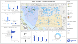
Benefits for Asset Managers
- A comprehensive workflow leveraging cloud-based data and a mobile workforce
- Share real-time data and updates with your workforce
- See status updates and data changes as they occur
- Track progress and re-allocate resources as needed
BENEFITS FOR PLANNERS AND DEVELOPERS
- Use 3D data to build interactive digital building models
- Calculate site-lines, viewsheds, shadows or sunshine
- Visualize proposed developments and potential impacts
- Navigate permitting and regulatory approval process with confidence
- Scalable from local development to smart city-wide planning